During my extensive travels in France in the 1970s I visited many places of interest but one of the most haunting was a beach on the right bank the Douve River estuary in Normandy. I was low on funds and had been hitching for days and found myself very near to what was known on D Day as Omaha Beach.
It was the summer of 1976 and even in Northern France the temperatures were in the low nineties which meant that al fresco camping was a must unless disturbed by the local gendarmerie.
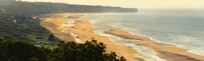 D Day had always fascinated me and to be able to explore Omaha Beach was an opportunity not to be missed. What I had not allowed for was the actual ordinariness of the area. I think I expected that as such a great battle had been fought there and on the other D Day beaches that there would be far more to see.
There were relics of the invasion and even inland the scars of war could still be seen (after all only thirty-two years had elapsed) but it seemed that nature was claiming back the history of the area. The German defences were rotting away in the heat and the greenery and occasionally the peace of the area was broken by the sound of teenagers riding their little pop-pop bikes towards the beach.
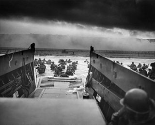
As it was so hot (and I had not washed for days) I decided to take a swim and it was then that the full impact of the area took hold. I was swimming in the gentle waters of the English Channel on that hot July day where only a generation ago many brave men would have died. I had a family at home to whom I was to shortly to return, but these soldiers were never to return and their last mortal memories would have been the terror of that long beach on that awful June day.
I spent some time drying off and was adopted by a kind French family who shared their lunch with me and it was whilst sharing my time with them that I realised why I found the whole area so haunting.
The beach was populated mainly by families and their children who were playing beach games with each other and their parents. In part it was for these families that these brave men waded ashore under heavy fire as they attempted to advance inland to liberate France from the Germans. I would like to think that a soldier who had taken part in the landings was there on that day and would have seen the families at recreation and would have known that the sacrifices would have been worthwhile.
 Omaha Beach in 1944 is a lifetime away from modern day Hungerford but if you look a little closer there are some similarities. Hungerford and the surrounding areas could have well been part of the front line if the Germans had invaded England in 1940. After our defeat at Dunkirk we were faced with the imminent threat of invasion as we obviously were never going to negotiate terms or surrender.
The Germans had two options to either invade or just wear us down though the channels of limited military action or by general propaganda and political warfare.
Although down on our knees being British we did not take this sitting down and within a very short space of time a complicated network of defences were erected with communication (nodal) points in certain places.
Hungerford was one of these as we were (and still are) in a position of strength in our small town. We have the two rivers and the canal the Bath and Salisbury Roads as well as the railway. Geographically the canal ran from Reading to Bristol and the railway towards Westbury and Taunton. The A4 also ran from east to west and because of the natural geography of Hungerford and the surrounding areas we were in a front line position whether we liked it or not.
If the Germans invaded then they would have looked to capture the main towns and cities but once captured these towns and cities would have had to have been supplied and this is where Hungerford amongst others became important. The canal, road and the railway would have been vital communication corridors.
During their invasion of France the Germans for the use of a better word cut loose and this was to some extent why the country fell so quickly. Our defence plan was to use the geography of the area as well as gun emplacements pillboxes and anti-tank traps to slow or stop the invasion if it happened.
On the 16th of July 1940 Hitler issued Directive Number 16 which was in effect the planned for the invasion of England. It was perceived that the invasion force would be ready by the August of that year and ready to sail on the 15th of the month. The codename for this operation was Sea Lion.
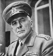 On the 27th of May 1940 Winston Churchill had put General Sir Edmund Ironside who was the Commander-in-Chief Home Forces in charge of organising our defences. He had a large number of men at his disposal but everything was somewhat fragmented to say the least. Ironside’s defence plan was simple and was to set up a static line of defence so that if we were invaded the Germans could be delayed (or maybe stopped) firstly on the beaches and then inland if they progressed. This would have enabled our mobile reserves to have helped to repel (or hopefully stop) the invader and by doing this their timetable of invasion would have been thrown off course.
The whole of Southern England (away from the separate coastal crust of armoured defences) would be a web of barriers (stop lines) which apart from taking advantage of the natural and industrial geography would be littered with anti-tank ditches, concrete pillboxes, gun emplacements and the like. Some of these defences were to be known as GHQ stop-lines and this is where Hungerford came in.
The main stop-line was obviously the most important and was designed to protect London and the industrial heartlands. It ran from the Taunton Stop Line in Somerset and followed the River Brue and the Kennet and Avon Canal to Reading then south of Guildford and Aldershot and London itself then on to Canvey Island in Essex before heading north towards Yorkshire and then Edinburgh.
As it was so large it was split into several sections.
Stop Line Green – this ran from Highbridge in Somerset in a large arc northeast to Trowbridge, Melksham, Lacock and Chippenham. It then ran in a north-westerly direction to Upper Framilode in Gloucestershire. The objective was to defend Bristol.
Stop Line Blue – (including Hungerford) branched off from Stop Line Green at Semington and followed the Kennet and Avon to Theale.
Stop Line Red – followed the Thames from Reading to Abingdon then across country to Newbridge (thus avoiding the Thames loop north to Oxford) and then across the Cotswolds to Great Somerford in Wiltshire.
There were other stop-lines in the country but these were the ones in the very general area of Hungerford.
Incredibly the defences were more or less complete by the September of 1940 (Ironside’s anti-invasion plan having been presented to the War Cabinet on the 25th of May 1940). It was called Home Forces Operations Instruction Number 3.
Thankfully the invasion never came as Hitler was getting a bloody nose from the brave pilots who were fighting in the Battle of Britain which took place from the July to the October of 1940. It was then he turned his attention other theatres of war which were equally disastrous for Germany.
The threat of invasion had receded but suppose we had lost the Battle of Britain and in time the Germans had invaded? Hungerford might have been in the front line of invasion with a great loss of life as our defences would have been tested to the full. Sadly I think that our little town would have suffered a great deal of damage and we might have lost many of our historical buildings as we were attacked by the Luftwaffe in the general softening up of the immediate area. The Salisbury Road and the Bath Road as well as the canal and railway would have been strategic targets and obviously Hungerford Common and the nearby downs would have come into the equation. Whether the Germans would have broken our stop lines is open to question and I am probably unqualified to answer that.
My parents who both lived through the invasion threat were always of the opinion that the invasion of Britain might have been a bridge too far for Hitler. My father often commented that whilst Russia had its winters, Britain had its stiff upper lip and its geography. Thankfully our defences were never put to the test and the Hungerford we see today is very much like the Hungerford of the 1940s. This said there are many relics of this time still to be seen.
As a child I lived in Bradford on Avon quite near to the canal and often we would play Japs & English in or near these pill boxes that were to be found in the area. Being a child you did not think much of these structures and ignored what your parents told you about how they were used as outdoor latrines and were most probably crumbling and therefore dangerous. They were just part of your rural environment.
Although I had known Hungerford for many years it was only when I moved here in 2007 that I really began to explore the area and I was pleasantly surprised to see how many structures had been preserved from this era. Preserved is probably the wrong word as most of these defences were in poor condition. Indeed the structures near Dun Mill Lock on the way to Kintbury seemed to be meeting places where our bovine friends could spend quality time together.
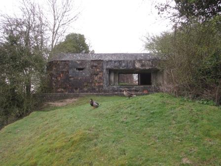 During the next couple of years I tried to find more relics of this era. The pill boxes near Dun Mill Lock are very easy to find. One has only to follow the line of the railway across the common (starting from The Downgate) and turn left at the railway bridge. The wartime structures are in front of you. If you travel from Theale to Bedwyn by train you will see the odd pill box and wartime defences near to the railway line.
With the help of (and quoting from) the fantastic Hungerford Virtual Museum website I will list a few structures in the area of the town.
Denford Mill: Near the road between Denford Mill and the bridge across the canal stands a classic hexagonal pillbox.
Sewage Pumping Station: This pillbox remains on the north side of the “swing bridge” at the end of Station Road. It stands on private property, and is obscured by the fence and foliage.
Near Highclose Farm: A pillbox remains north of the railway to the west of Highclose Farm.
There were other defences (now removed)
Hungerford Town Lock: This pillbox was removed (with great difficulty!) when the Kennet & Avon Canal was restored at Hungerford in 1974. It stood on the north side of Hungerford lock.
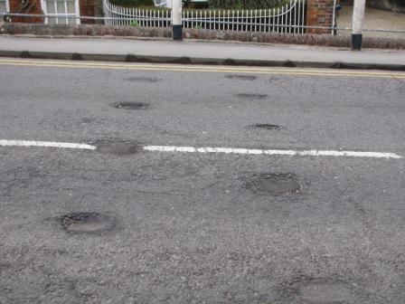 Hedgehogs: In addition to the pillboxes, it was necessary to adopt a strategy to impede any invading troops using bridges across the canal. Many techniques were adopted, including ‘dragon’s teeth’, ‘cylinders’, ‘hairpins’ and ‘cubes’. Evidence of the planned use of ‘hedgehogs’ on the main canal bridge in Hungerford High Street can be seen where the tarmac surface is collapsing into the ‘hedgehog’ sockets.
Gun emplacement in High Street: There was a major gun emplacement near Church Lane which was designed to take a 6-pounder gun, and this was accompanied by permanent concrete road blocks and a “hedgehog” under the railway bridge.
I also have found anti-tank defences whilst walking between Hungerford and the Crofton Pumping Station (a distance of about six miles). Some of these are still in situ on a bridge over the canal and others can be seen near a railway crossing. And, if you look in the general landscape of the area you can mysterious recesses which are likely to date from the last war (although some are older, especially the ones on Hungerford Common)
Hungerford is a peaceful place and it takes a considerable amount of imagination to think that it might in part have been in the front line if the German’s had invaded. But if the dice had fallen on to a different number then this might have been the case and visitors to the town in 2015 might have explored the area and wondered like I did on Omaha Beach how such a peaceful place could have had such bloody history.
Thankfully this did not happen and we can explore these primitive structures safe in the knowledge that they were never used.